Real Estate · Land
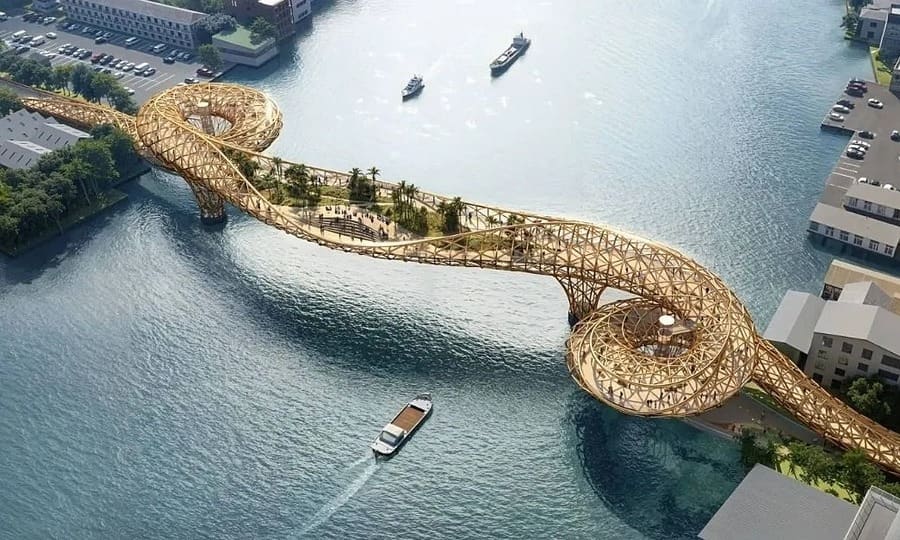
Bangkok to Build $29 Million Pedestrian Bridge Linking Historic Districts
The 300-meter span across the Chao Phraya River will connect two riverside neighborhoods and integrate with the city's MRT network by 2030.
KEY TAKEAWAYS
- ·Bangkok will construct a THB1 billion pedestrian and cycling bridge spanning 300 meters across the Chao Phraya River, connecting Songwat and Khlong San districts by 2030.
- ·The project addresses a critical gap in non-motorized river crossings, with current options limited to vehicle-heavy bridges and time-restricted ferry services.
- ·Integration with MRT stations and rooftop vendor spaces aims to create economic activity while reducing transit disparities between riverside neighborhoods.
A New River Crossing for Non-Motorized Traffic
Bangkok authorities have committed THB1 billion (US$29 million) to construct a dedicated pedestrian and bicycle bridge spanning the Chao Phraya River, addressing a longstanding gap in the city's green transportation infrastructure. The Bangkok Metropolitan Administration announced the project will link the historic Songwat and Khlong San districts, with completion targeted for 2030.
Governor Chadchart Sittipunt said the bridge will establish a landmark dedicated exclusively to people moving on foot or by bicycle, marking a departure from the city's vehicle-centric river crossings. The structure will measure 300 meters in length and up to 10 meters in width, connecting directly to pedestrian routes that feed into the MRT network.
The project addresses a practical challenge faced by thousands of Bangkok residents. Current options for crossing the river without a motor vehicle remain limited and often hazardous. Existing bridges prioritize heavy vehicle traffic, while ferry services operate only during restricted hours, leaving pedestrians and cyclists with inadequate alternatives during much of the day.
Design Minimizes Community Disruption
Project planners have designed the bridge to avoid requiring new land expropriation, a decision intended to preserve the character of long-established riverside communities. The approach contrasts with previous infrastructure projects that displaced residents and altered neighborhood fabric.
The design incorporates rooftop spaces on adjacent buildings, which will be converted into areas for community shops and street food vendors. This element aims to generate economic activity for local businesses while creating gathering points at either end of the crossing.
Pichai Wongwaisayawan, dean of the Faculty of Architecture at Bangkok University, characterized the bridge as social infrastructure rather than merely physical infrastructure. The structure's value, according to Pichai, lies in its capacity to integrate multiple transportation modes, including trains, boats, walkways, and bicycles, into a coherent network.
Bridging Economic and Geographic Divides
Governor Chadchart framed the project within his administration's broader policy of developing people-focused infrastructure alongside traditional road networks. He noted that the bridge will help reduce economic disparities between the Phra Nakhon side and the Thonburi side of the river, areas that have historically received uneven development attention.
The connection between Songwat and Khlong San holds particular significance. Both districts contain concentrations of historic architecture and cultural sites, yet pedestrian access between them has remained difficult. The new crossing is expected to increase foot traffic to businesses and cultural institutions on both banks.
Pichai emphasized that the bridge's long-term impact depends on whether it becomes part of a larger network of riverfront walkways. If the structure functions only as an isolated destination, its utility will remain limited. If it serves as the first link in an expanding chain of pedestrian routes connecting communities and public transit nodes, the infrastructure could reshape how residents navigate the city.
Regional Context for Pedestrian Infrastructure
The Bangkok bridge reflects a broader pattern of Asian cities investing in pedestrian and cycling infrastructure as congestion and air quality concerns intensify. Singapore expanded its park connector network to over 300 kilometers in recent years, while Seoul converted a former elevated highway into the Seoullo 7017 pedestrian skyway in 2017. Jakarta opened its first dedicated bicycle lane network in 2020, though enforcement of vehicle encroachment remains inconsistent.
Bangkok's project distinguishes itself through its integration with existing mass transit. By connecting pedestrian routes directly to MRT stations, the bridge creates viable alternatives to motorized transport for trips that combine rail and walking. This approach addresses a common weakness in Asian urban planning, where last-mile connectivity often undermines otherwise efficient public transit systems.
The 2030 completion timeline positions the bridge within Thailand's broader National Transport Master Plan, which calls for expanding non-motorized transport infrastructure across major cities. The plan allocates THB50 billion for pedestrian and cycling projects through 2035, with Bangkok receiving the largest share of funding.
Whether the Chao Phraya bridge catalyzes further pedestrian infrastructure or remains an isolated project will depend on funding priorities and political will in subsequent administrations. The structure's success will be measured not just in crossing volumes, but in whether it shifts commuter behavior and sparks additional investment in walkable urban design.
RELATED STORIES
Thailand Faces Two Decades in Middle-Income Trap Without Workforce Upgrade
Priyanka V. Rao · 3 min
Thailand Faces Twin Labour Pressures as Manufacturing Slows
Siti Nuraini · 4 min
Thailand Unveils Excise Tax Cuts to Boost Local Auto Parts Sourcing
Siti Nuraini · 3 min

Roojai Sets 6% Market Share Target as Thailand Insurer Pivots to Health
Priyanka V. Rao · 3 min
Spot something wrong? Email editor@briefasia.com. We log every correction publicly.